The Himalayas Have Collapsed... Nepal's Mega-Flood Differs from Typical 'Glacial Lake Outbursts'
Torrential Disaster Triggered by Glacier and Rock Collapse Near Langtang Lirung... As of August 29, Nepal Records 626 Deaths and 2,426 Missing, with Damage Spreading to Hydropower Infrastructure in the Trishuli River Basin
Core Summary
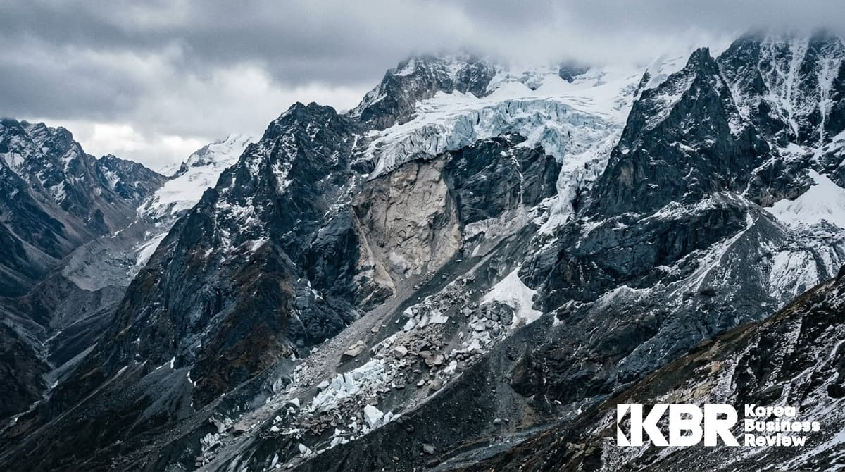
The mega-flood that struck northern Nepal and the border of the Tibet Autonomous Region of China on August 26, 2026, was a torrential disaster difficult to explain solely by local monsoon rainfall. Expert analysis based on the US Geological Survey (USGS) and satellite imagery leans toward a massive glacier and rock collapse in the high-altitude region near Langtang Lirung, 7,234 meters above sea level, as the direct trigger for the disaster. It appears that the collapsed ice, rock, and soil poured into the upper valley, causing widespread damage down the Bhotekoshi and Trishuli river basins.
According to initial satellite imagery and expert analysis, this disaster appears to be a type where glacier and rock slope collapse combined with valley blockage and its subsequent failure may have occurred, rather than a typical Glacial Lake Outburst Flood (GLOF) caused by the bursting of a glacial lake dam. However, the chronological sequence and contribution weight of each stage can only be finalized after field investigations are completed.
Casualties continue to rise as tallying progresses. As of August 29, the National Disaster Risk Reduction and Management Authority (NDRRMA) of Nepal recorded 626 deaths and 2,426 missing or unaccounted-for persons. Separately, 7 deaths and 554 missing persons were reported in Gyirong County, Tibet Autonomous Region, China. A simple addition yields at least 633 deaths and 2,980 missing, but the actual scale may be lower as duplication between the two lists has not been verified. Given that these figures were produced amidst widespread communications and power outages, some among the missing may simply have unconfirmed safety rather than being confirmed lost. As rescue operations are ongoing, the figures continue to fluctuate. Additionally, 9 South Koreans are out of contact at the Upper Trishuli-1 (UT-1) hydropower plant construction site being built by Korea South-East Power and Doosan Enerbility.
The implications of this event from a corporate and investor perspective are clear: the climate risk assessment frameworks for overseas infrastructure projects are failing to keep pace with the types and speeds of disasters actually occurring.
What Happened
The incident occurred around 8:37 AM local time on August 26. The US Geological Survey (USGS) initially classified the signal captured near the Nepal-China border as a magnitude 4.4 earthquake, but following a reanalysis, corrected it to a massive slope collapse and debris flow event equivalent to a magnitude 5.2, noting it was not an actual earthquake. The scale of the collapse was so large that signals were registered on seismographs around the world.
The path of the flow is relatively clear. Water and sediment from the collapse zone flowed into Rende Kola in the high borderlands, then spread via the Bhotekoshi River into the Trishuli River basin. The torrent rapidly swept through downstream gorges and settlements over a distance of about 100 km. Some early reports stated that water levels in the Trishuli River surged by up to 9 meters in 30 minutes, but the extent of the water level rise and the speed of the torrent have not been confirmed by hydrological observation data. What is clear is that the torrent arrived too quickly for residents to secure time for evacuation.
The area that suffered the worst damage was Rasuwagudha, located just south of the Chinese border. Settlements such as Timure and Syabrubesi took the direct hit, and flooding continued downstream into Nuwakot and Dhading districts. The Nepali government issued flood warnings for riverside areas including Rasuwa, Nuwakot, Dhading, Gorkha, and Chitwan. A day after the flood occurred, bodies presumed to be victims were recovered from downstream rivers near the Indian border.
Infrastructure damage is also extensive. The NDRRMA stated that dozens of kilometers of major roads and dozens of bridges were washed away across a wide area. With power and communications completely cut off in the accident area and road access blocked, Rasuwa, the hardest-hit area, remained accessible virtually only by helicopter.
Identifying the Cause: Glacier and Rock Collapse Hypothesis Overweight Typical GLOF
Immediately after the disaster, the cause first pointed out by experts was a Glacial Lake Outburst Flood (GLOF). GLOFs are a phenomenon where the natural dams of high-altitude lakes created by retreating glaciers collapse, causing massive amounts of water to rush downstream all at once—a hazard repeatedly warned of in the Himalayan region. Indeed, in the early stages of the accident, many domestic and foreign media outlets reported this disaster as a GLOF.
However, once satellite imagery became available, the explanation shifted. Geomorphologists Christine Cook and Dan Sugar of the University of Calgary in Canada stated that while images from the day of the accident were obscured by clouds and debris dust, confirming only that a part of the glacier had broken off from Langtang Lirung peak, clearer images acquired the following day revealed evidence that the bedrock itself beneath the glacier had collapsed. Professor Sugar explained that it was not a single glacier collapsing, but a much larger rock mass on the mountain slope giving way entirely, dragging a portion of the glacier down with it. Collapse traces captured by the Landsat 9 satellite supported this analysis.
However, going a step further in description requires caution. Some foreign and domestic media reports conveyed an interpretation that the fallen debris temporarily blocked a narrow valley, trapping water before the blockage gave way and burst out as a torrent. While the possibility that blockage and release played a role is well worth examining, the role this process played in the initial mega-flood and its sequential order must await the completion of field investigations. Confirmed facts at this stage go only as far as stating that a massive glacier and rock collapse created a flow mixed with water, ice, sediment, and rocks that struck downstream.
The formation of a landslide-dammed lake by collapse debris blocking the upper river is separately verified. As this lake began to overflow on August 28, rescue operations in the border area were temporarily suspended, and it is subsequently reported to have been virtually drained, somewhat lowering the risk of secondary flooding. However, this was the situation two days after the disaster occurred and needs to be distinguished from the cause of the initial flood.
This distinction goes beyond an academic difference. GLOFs can be predicted and managed to some extent by creating inventories of hazardous glacial lakes and monitoring water levels and dam conditions. In contrast, bedrock collapse beneath a glacier is much harder to detect through surface observations alone. This implies that even with an early warning system in place, virtually no response time is afforded for this type of disaster.
Background: Himalayan Glacier Loss Doubled in Speed
A final conclusion on why the bedrock collapsed has not yet been reached. Experts believe that glacier retreat due to global warming, thawing permafrost, and the penetration of meltwater into rock fractures can weaken the stability of high-altitude slopes. They explain that as temperatures rise and glaciers retreat, the ice supporting the mountain slopes disappears, and as permafrost—which has bound rock and soil together for thousands of years—melts, the structural stability of the bedrock declines. However, the direct cause of this collapse and the contribution of each factor are still at a stage requiring further investigation.
Background indicators have been accumulating. According to a report released by the Kathmandu-headquartered International Centre for Integrated Mountain Development (ICIMOD) in March 2026 to mark World Glaciers Day, the average rate of glacier loss in the Hindu Kush-Himalaya (HKH) region nearly doubled from about 34 cm per year prior to 2000 to approximately 73 cm per year thereafter. It was analyzed that about 12% of glacier area disappeared between 1990 and 2020.
What is noteworthy is that these risks have hitherto been managed primarily through glacial lake inventories—a method of designating hazardous glacial lakes and monitoring water levels and dam conditions. However, if this incident occurred in a manner different from the types targeted by that framework, a review of the existing risk classification system itself becomes inevitable.
Case Study ①: UT-1 Halts at 84% Completion
From the perspective of South Korean companies, the direct damage from this disaster was concentrated at the Upper Trishuli-1 (UT-1) hydropower plant site. UT-1 is a 216 MW run-of-the-river hydropower plant being constructed on the Trishuli River, about 70 km northwest of Kathmandu. The total project cost is $647 million, with a creditor group of 9 institutions participating, including the Export-Import Bank of Korea, the International Finance Corporation (IFC), the Asian Development Bank (ADB), and the Asian Infrastructure Investment Board (AIIB). Korea South-East Power (KOEN) and Korea Overseas Infrastructure & Urban Development Corporation (KIND) are major shareholders, with Doosan Enerbility serving as the EPC contractor. It carried the symbolic significance of being Nepal's first private power generation project involving South Korean companies.
The power plant consists of a weir, a headrace tunnel, and an underground power station. KOEN had been proceeding with the project aiming for completion by the end of 2026, planning to directly operate it for 30 years post-completion and sell 1,456 GWh of electricity annually to the Nepalese government. It was a long-term project taking 15 years from when KOEN first participated in development in 2011 to the target completion date.
The extent of damage is severe. According to initial assessments by the project operators, with the project at 84% completion, over 90% of upper hydraulic and cut-off facilities including the weir, and about 90% of the base camp where construction workers stayed, were damaged. Yoon Jang-hyun, head of KOEN's New Growth Business Division, conveyed this situation prior to his departure for Nepal on August 27, stating that the underground power plant was understood not to have been buried. However, this was an initial judgment made under conditions of limited site access, and the damage range for each facility and the status of underground structures must await precise investigation.
What is more noteworthy is that UT-1 is not an exception. According to figures released by the Independent Power Producers' Association, Nepal (IPPAN) on August 29, 13 hydropower projects suffered direct damage from the flood and landslides, and at 11 of them, 934 people were identified as out of contact. Of these, 254 people were rescued and some subsequently regained contact, but the whereabouts of a significant number remain unverified. As rescue operations are ongoing, the number of sites and people continues to be adjusted.
Breaking down by business site, 730 people were tallied across 6 sites in Rasuwa District, and 204 people across 5 sites in Nuwakot District. At UT-1 alone, the whereabouts of 576 people were unaccounted for; approximately 1,350 people worked at this site. Other affected facilities included the operational 111 MW Rasuwagadhi, the 60 MW Upper Trishuli-3A, and the 37 MW Upper Trishuli-3B under construction. The Nepalese army has focused on rescuing personnel trapped in tunnels and underground power stations, but there are not a few sites where even the location of the entrance is difficult to identify.
What these figures state clearly is that this disaster was not the bad luck of a specific project site, but a structural reality in which entire hydropower infrastructures concentrated in a single river basin were exposed together to the same upstream risk.
The casualties are even more heartrending. The whereabouts of 9 South Koreans, including 3 KOEN employees and 6 personnel related to Doosan Enerbility, remain unconfirmed. Both companies hurriedly dispatched management to the site, and the government deployed a joint rapid response team headed by Lim Sang-woo, government representative for overseas Korean nationals' protection and consular affairs, to continue helicopter searches. However, although the government and the two companies chartered 6 helicopters, the Nepalese military authorities withheld takeoff approval citing concerns over secondary flooding and worsening weather, imposing constraints on the search. The government provided estimated movement path coordinates to the Nepalese side based on the missing persons' work itineraries. The Ministry of Foreign Affairs issued a special travel advisory for 4 provinces—Bagmati, Gandaki, Koshi, and Lumbini—on August 28.
A notable point is that preparations were not entirely absent. Considering the frequent flood characteristics of the region, Doosan Enerbility and KOEN had established early warning systems and conducted evacuation drills. Even so, in the face of the speed at which debris flows rushed down, no time itself was secured for the existing response systems to operate.
Case Study ②: Severance of Gyirong Port and Border Logistics
The damage was not limited to Nepal. The Gyirong Port area in Xigaze, a major trade and tourism gateway connecting Nepal and China, was also directly hit by debris flows. Emergency management authorities in China's Tibet Autonomous Region tallied 550 missing persons along with fatalities, with 260 of them identified as foreigners. The Tibet side's initial rescue team reached the hardest-hit area of the Gyirong border checkpoint on foot on the afternoon of August 28, the third day.
The composition of the missing persons demonstrates the international character of this disaster. Foreigners from over 31 countries were included on the list, and tourists, trekkers, and pilgrims accounted for a significant portion. Many of them were people who had set out on the pilgrimage route to Mount Kailash. Because detailed breakdowns by country vary depending on the timing of announcements by various diplomatic authorities, it is necessary to view the data centered on aggregate totals. China dispatched professional personnel with tunnel rescue experience to the Nepalese side.
Gyirong Port is a core passage for overland trade and tourist movement between Nepal and China. The physical destruction of this point leads to a direct blow to Nepal's import logistics from China and the Himalayan tourism industry. Considering the proportion that tourism, remittances, and border trade occupy in Nepal's economy, the recovery period itself is a matter that can be reflected in macroeconomic indicators. Glacier disaster experts worry that it will take years to restore the devastated areas.
The Time Lag in Risk Assessment
The point that corporations and investors must take most heavily from this incident is the time lag in risk assessment. Some domestic media outlets cited project data for UT-1 disclosed by the ADB, reporting that a climate change risk assessment conducted in the past judged the climate-related risks of this project to be 'low.' However, this publication was unable to directly verify the original document containing the timing of the assessment, the risks evaluated, and the methodology. This point remains a matter requiring further verification.
Regardless of whether the original document is verified, the time lag issue itself is real. This is because climatic conditions surrounding the project site changed considerably during the 15 years that elapsed from when KOEN first participated in the project in 2011 to the target completion date.
There are also structural problems. Due to the nature of hydropower utilizing the head of water, it is bound to be constructed in mountainous and valley terrains, exposing it that much more to landslides and flash floods. The stronger the project justification of securing clean energy and contributing to carbon neutrality, the narrower the freedom of choice for location selection actually becomes. A paradox is established whereby infrastructure for responding to climate change is placed in positions most vulnerable to climate-related disasters.
A vacuum in observation infrastructure also heightens risks. ICIMOD has pointed out that glacier observation networks across the Himalayas remain sparse, points meeting international standards are limited, and key regions such as Karakoram, Bhutan, and Sikkim remain in observation blackouts. The report's expression is that we are navigating a rapidly changing future with incomplete data. It is a point to bear in mind operationally that the less data-deficient a region is, the higher the likelihood that project risk assessments will come out optimistically.
On the financial side, issues such as increased financing costs due to construction delays, determination of the scope of rework, application scope of insurance coverage, and risk-sharing structures between the ordering party and the contractor are projected to emerge sequentially as contentious points. In particular, how this type of natural disaster is handled in project financing structures involving multilateral development banks in large numbers can serve as a reference case for future overseas infrastructure bidding conditions for South Korean companies.
Outlook and Checkpoints
The secondary disaster risk, which was the greatest short-term variable, has cleared its first hurdle for now. ICIMOD warned that blockages remain upstream of rivers in the border region, which could trigger a second flood, and as the debris-formed lake began to overflow on August 28, rescue operations in the border region were temporarily suspended. This lake is subsequently reported to have been virtually drained. However, additional rainfall is forecasted due to monsoon influences, and it is premature to feel reassured given that further rain on destabilized slopes could elevate risks once again.
Over the medium term, three things need to be checked. First is the official damage assessment of the 13 affected business sites, including UT-1, and their project resumption schedules. Once the scope of destruction of the upper intake facilities is finalized, the scale of rework and the extent of completion delays can be estimated. Second is whether climate risks are reassessed for other infrastructure projects involving South Korean companies underway in neighboring Himalayan countries. Third is whether multilateral development banks and export credit agencies will raise climate risk assessment criteria for mountainous projects. If standards are raised, they will be directly reflected in insurance premiums and financial terms for new projects.
Over the long term, the trajectory of Himalayan glaciers itself will determine regional risk premiums. ICIMOD forecasts that even if global average temperature increases are capped below 2 degrees Celsius, glaciers in this region could lose 30% to 50% of their volume by 2100. If this outlook is maintained, high-altitude slope destabilization issues are likely to be raised repeatedly in the future. For operators exposed to South Asian infrastructure, tourism, and water resource assets, now is the time to re-examine not only disaster response manuals but also the very premises of the site selection stage.